Flickr image 4.5 MB or click on image below
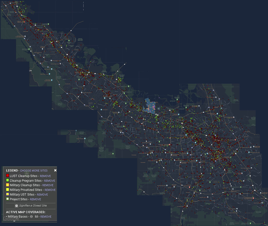
Silicon Valley Composite image of GeoTracker map showing toxic waste sites. Geotracker uses Google images.
The Navy Nuked San Francisco
Flickr image 4.5 MB or click on image below
Silicon Valley Composite image of GeoTracker map showing toxic waste sites. Geotracker uses Google images.

On the left is a nuclear reactor core, on the right is the Palo Alto Baylands Nature Preserve Trailhead. This company would have a nuclear disaster in a sister plant in New Jersey which resulted in the closure of all of their plants nationwide due to mismanagement.
International Nutronics Inc ran the Palo Alto reactor also had a reactor in Dover New Jersey (below) that had a serious nuclear accident which the company did not report to the NRC and this resulted in the closure of this reactor in Palo Alto. The company started off at 200 Third St. Los Altos but they had three reactor sites, one in Irvine and this one and the Dover New Jersey plant and a sewage Treatment plant in Menlo Park where they irradiated sewage to kill bacteria.
The Palo Alto facility had 750,000 Curies of C0-60 source and was used to irradiate food to kill bacteria and for cleaning medical equipment. Basically they would place these things in containers over the reactor and open it up to be irradiated.
“The potential personnel radiation exposure hazard posed by the sources at large irradiators is substantial. For example, the unshielded dose from a 250,000 Ci Co-60 source is approximately 250,000 rem/hr (69 rem/sec) at 4 feet and approximately 25,000 rem/hr (6.9 rem/sec) at 13 feet. Therefore, a lethal dose could be received within minutes.” – Review of Events at Large Pool-Type Irradiators, E.A. Trager, Jr., Division of Safety Programs Office for Analysis and Evaluation of Operational Data U.S. Nuclear Regulatory Commission Washington, DC 20555 March 1989
Continue reading “Palo Alto Nuclear Reactor at Baylands Nature Preserve Trailhead and the Dover Nuclear Disaster”
EPA Superfund Site Link 620-640 PAGE MILL RD PALO ALTO, CA 94304-1001
Geotracker State of California website link for the site
POTENTIAL CONTAMINANTS OF CONCERN
1,1,1-TRICHLOROETHANE (TCA), ARSENIC, TETRACHLOROETHYLENE (PCE), TRICHLOROETHYLENE (TCE)
Deed Restrictions: ACTIVITIES PROHIBITED WHICH DISTURB THE REMEDY AND MONITORING SYSTEMS WITHOUT APPROVAL, LAND USE COVENANT, NOTIFY DAMAGES TO REMEDY AND MONITORING SYSTEMS UPON DISCOVERY
HEWLETT-PACKARD COMPANY (SL720511210) – (Geotracker MAP) Map indicating toxic waste sites in as small square boxes. If you click on each square you will be directed to the State Geotracker page for that toxic waste site.
Geotracker map for 5/1/2018 showing the toxic wastes sites in the area area affected and the well sites to monitor the groundwater.
Groundwater Contamination Map, Toxic Plumes Map Source: The Chemical Legacy of Old Silicon Valley, NBC Bay Area, Map Editor Scott Pham 2019 The red dots represent Daycare centers from 2019. NBC Bay Area had a series of maps that indicated where the toxic waste sites were located and the extent of the damage encompassing vast areas of the community but they took it down. The pollution is in the groundwater so it covers a vast area in Pink.
Map Source: The Chemical Legacy of Old Silicon Valley, NBC Bay Area, Map Editor Scott Pham
Testing finds hazardous TCE under some College Terrace homes. by Sue Dremann/ Palo Alto Weekly Thu, Jun 30, 2016, 11:19 am https://www.paloaltoonline.com/news/2016/06/27/testing-finds-hazardous-tce-under-some-college-terrace-homes
State regulatory agency previously dismissed trichloroethylene risk
Note the comments where local people talk about the sites that they live on and the horrible consequences in sites other than this one!
Discovery of toxic chemical prompts changes in Stanford’s housing project Palo Alto Online
Palo Alto reviews new plans for 1601 California Ave. after trichloroethylene is found in soil
by Gennady Sheyner / Palo Alto Weekly Uploaded: Wed, Dec 16, 2015, 2:01 pm
Stanford University website; Faculty Housing, University Terrace Frequently Asked Questions
NBC Bay Area Video on the Toxic waste sites all over Silicon Valley. They had an interactive map but they took it down from their website.
Original article: NBC map showing the hundreds of sites on a map so you can see if you are affected by the pollution of Silicon Valley. https://www.nbcbayarea.com/brchannel/Map-The-Chemical-Legacy-of-Silicon-Valley-258950021.html From this map you can see that Apple and Google Headquarters are located on 2 superfund sites each where the polution is TCE Trichloroethylene where there are restrictions that require no person under the age of 21 can occupy any building built on the properties.
There is Kaiser Permanente building for Children and Adult psychiatric care built right on top of the street address of three sites and two of them are under Apple which is across the street. Note the tabs to show the daycare facilities that are on the purple areas that are mapped out to show the pollution.
The Map Article was taken down by NBC Bay Area.

You must be logged in to post a comment.