The Site is the proposed location of a bikeway connecting Maritime Street in Oakland and Shellmound Street in Emeryville. The proposed area was historically used for industrial, commercial or vehicle transportation corridors.
Cypress Freeway/Bikeway Project, Land Use Covenant and Agreement, 03/03/2016 Official Records of Alameda County, p 16
(a) A residence, including any mobile home or factory built housing, constructed or installed for use as residential human habitation. (b) A hospital for humans. (c) A public or private School for persons under 18 years old. (d) A day care center for children
POTENTIAL CONTAMINANTS OF CONCERN
Hazardous substances, including arsenic at 0.39 ppm, mercury at 2.1 ppm, lead at 190 ppm, and total petroleum hydrocarbons (TPHd) at 1,100 ppm remain at the Property above levels acceptable for unrestricted land use.
Note this was cleaned up to this standard which is fine for industrial use.
The site was formerly part of the Judson Steel Corp. founded in 1882. Judson Steel mainly used the site for storage and disposal of slag material. Metals (lead, chromium, etc) were present in the soil and hydrocarbons and volatile organics appear to be migrating via groundwater from surrounding properties. The source of the hydrocarbon contamination in the groundwater is believed to be the former PIE site located to the north. Under the authority allowed by the Polanco Bill, the City of Emeryville Redevelopment Agency granted liability immunity to Marriott Corporation.
ACTIVITIES PROHIBITED WHICH DISTURB THE REMEDY AND MONITORING SYSTEMS WITHOUT APPROVAL ASPHALT COVER NOT TO BE DISTURBED WITHOUT APPROVAL DAY CARE CENTER PROHIBITED ELDER CARE CENTER PROHIBITED HOSPITAL USE PROHIBITED LAND USE COVENANT NO EXCAVATION OF CONTAMINATED SOILS WITHOUT AGENCY REVIEW AND APPROVAL NO OIL OR GAS EXTRACTION AT ANY DEPTH NOTIFY PRIOR TO SUBSURFACE WORK PUBLIC OR PRIVATE SCHOOL FOR PERSONS UNDER 21 PROHIBITED RAISING OF FOOD PROHIBITED RESIDENCE USE PROHIBITED Continue reading “Emeryville CA – SHELLMOUND VENTURE PROJECT (01330039)”→
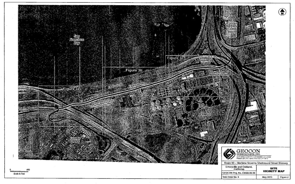
Envirostor Deed Restriction South Bayfront Property Shellmound Street Emeryville Alameda County Parcel #s 049-1038-007, 049-1038-0.081 049-,1038-001-1,049-1038-001-4, 049-1038-002; 049-1038-003; 049-1516-006-2, 049-1516-007-2 and the former Shellmound Street right-of-way) p. 25
Site History
The history of the site included industrial usage of the various parcels including Elementis Pigments at 4650 Shellmound Street, McKinley Property at 5500 Shellmound Street, and the Sepulveda Property at 5600 Shellmound Street (Shellmound Properties). Since 1929, Elementis Pigments produced iron oxide for paint pigments and other uses. Sherwin Williams owned the McKinley and Sepulveda properties until 1965 and 1955, respectively. Sherwin Williams operated a lime and sulfur plant and an insecticide and spray plant. Other usages included a sign shop, a photo shop, a machine shop, and commercial offices at the McKinley Property. A truck and trailer storage yard and equipment rentals used the Sepulveda property. The southern portion of the site includes the former Myers Drum site which historically was used for drum cleaning and recycling. Continue reading “Emeryville CA – SOUTH BAYFRONT PROJECT (01890019)”→
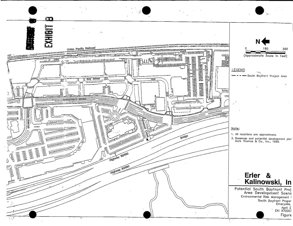
The Brentwood Gun Club began operation at the site in 1964. The facility had a trap and skeet field, rifle and pistol ranges, and an air gun range. Prior to that the property was used as a sanitary landfill. Contra Costa County acquired the property in August 1999 in preparation for the construction of the State Route 4 Bypass through the site. A Removal Action Workplan was implemented for consolidation of lead-contaminated soil under the proposed roadway and capping contaminated outside of the freeway footprint with 1-2 feet of clean fill. Some soils that exceeded residential screening levels but were below commercial screening levels for lead were left in place without a cap. A Land Use Covenant was filed with the County Recorder that restricts future usage of the site for residential, child care, or school facilities. Annual inspections are required as part of Operations and Maintenance.
Editors note; this deed restriction is current and yet it is a housing development even though it is prohibited in the land use covenant.
COVENANT TO RESTRICT USE OF PROPERTY ENVIRONMENTAL RESTRICTION Re: County of Contra Costa APN#007-110-013 and portion 010-020-004, Former Brentwood Gun Club Site, 731 Concord Avenue, Brentwood, California page 22
Raychem Corporation (Raychem) operated a facility which manufactured high technology plastic and electrical insulation products and also engaged in management of hazardous waste pursuant to a hazardous waste facility permit (Permit). The Permit, issued in 1983 by the California Department of Health Services, the predecessor of DTSC, allowed operation of a wastewater treatment system, a hazardous waste storage yard and a potassium ferrocyanide tank farm. On January 9, 1997, DTSC approved the closure activities of aboveground portions of these hazardous waste management units. Continue reading “FACEBOOK MENLO PARK WEST CAMPUS (60001437) VOLUNTARY CLEANUP”→
“The Site covers approximately 0.9 acre and was used for an orchard and flower growing business. Sequoia Union High School District (SUHSD) purchased the Site and planned for construction of a school facility for a charter school. The construction consisted of classrooms, a gymnasium and paved parking areas. The school campus is an expansion of the adjacent campus at 1010, 1020, 1040 and 1056 Myrtle Street (Site Code 204238) that was cleaned up under DTSC’s oversight in early 2011. In September 2013, SUHSD entered into a voluntary cleanup agreement with DTSC for cleanup of the soil contamination. The Site was cleaned up by soil excavation, capping and offsite disposal. Soil contaminated with arsenic, lead, dieldrin and DDT was excavated from classroom building locations and consolidated in a 0.5-acre area onsite that will be used for parking and gymnasium. Approximately 305 cubic yards of excess contaminated soil that cannot be used onsite was disposed of to a permitted landfill. The Site cleanup and school construction was completed in September 2014.” Continue reading “East Palo Alto – MYRTLE STREET HIGH SCHOOL CAMPUS PHASE 2 (60001925)”→
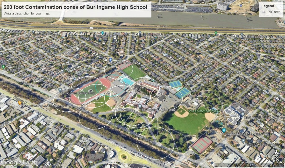
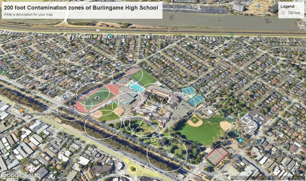
Burlingame High School is a perfect example of how the state of california defines toxic waste sites by fence lines instead of by distance to the toxin which is what everyoen else in the entire world does when it comes to saftey. Teh rest of the world defienes a toxic waste site by distance, for example the EPA defiens everything within 200 feet of a toxin is on a toxic waste site. The State of California defines it by fence line, property line. So if they find a toxic substance they fence in off, declare that a separate property and then decide on cleianing it up as the docket grows. They have removed it from the school site by declaring it a separate property.
Here is the map for Burlingame High School, the circles are the distance measurements from the toxic sites which include the grassy area in front of the school. The entire school should be evacuated and the state has a lot of explaining to do.
Envirostor (State of California) page for MARINA VISTA PROJECT (38270353) 725 2ND STREET (75 & 99 TOWNSEND) SAN FRANCISCO, CA 94107
“The 78,000 square foot site has been developed into a 14-story high-rise residential building with both retail stores and living units on the first floor. The City of San Francisco oversaw the installation of the cap.”
Deed Restrictions: ACTIVITIES PROHIBITED WHICH DISTURB THE REMEDY AND MONITORING SYSTEMS WITHOUT APPROVAL, LAND USE COVENANT, NOTIFY DAMAGES TO REMEDY AND MONITORING SYSTEMS UPON DISCOVERY
HEWLETT-PACKARD COMPANY (SL720511210) – (Geotracker MAP) Map indicating toxic waste sites in as small square boxes. If you click on each square you will be directed to the State Geotracker page for that toxic waste site.
Geotracker map for 5/1/2018 showing the toxic wastes sites in the area area affected and the well sites to monitor the groundwater.
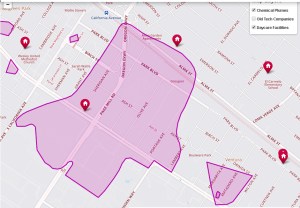
Groundwater Contamination Map, Toxic Plumes Map Source: The Chemical Legacy of Old Silicon Valley, NBC Bay Area, Map Editor Scott Pham 2019 The red dots represent Daycare centers from 2019. NBC Bay Area had a series of maps that indicated where the toxic waste sites were located and the extent of the damage encompassing vast areas of the community but they took it down. The pollution is in the groundwater so it covers a vast area in Pink.


You must be logged in to post a comment.