Featured

6 Nuclear sites within walking distance of California Department of Public Health Building, UC Berkeley Richmond and EPA Region 9 Lab

If the State and the Feds cannot look out for its own people how can we rely on them to protect the public?

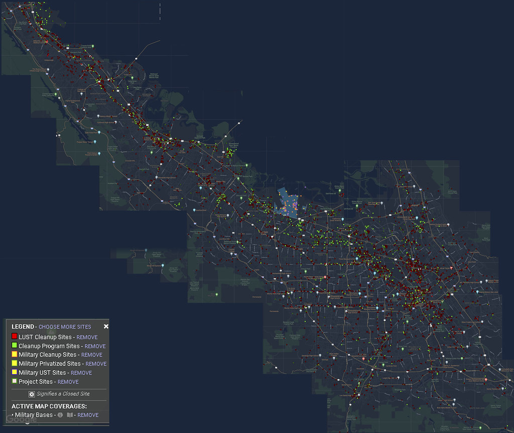
The Califormia Department of Public Health (CDPH) regulates all of the radiological contamination in the State of California. The California Department of Public Health (CDPH) Building, EPA Region 9 lab and the University of California Berkeley Richmond Campus are located right in the heart of Nuclear Alley in Richmond CA. This series will highlight 6 nuclear industry companies in the Port of Richmond that held Atomic Energy Commission Licenses for Nuclear Waste, worked directly with radioactive isotopes (radioactive elements like Uranium, Plutonium, Strontium 90, Cesium 137, Cobalt 60, Carbon 14 etc) and built machines used in the Nuclear Weapons industry.

Tracerlab/EAL building at 2030 Wright Avenue has been looted, it is a nuclear waste site and made radiological equipent for the Nuclear Industry. Google maps street view

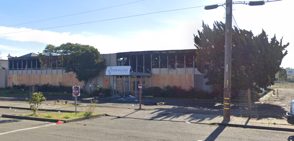
All are within walking distance of these government facilites and they have never been cleaned up for their nuclear purposes. These government facilities need to be evacuated, because they were constructed after the contamination, which means:

  • Every surface exposed during contruction inside the walls and out will have to be swabbed to determine alpha and beta particles for identification of the isotopes as well as gamma readings for radiation.
  • All samples taken as evidence for all of Region 9 which includes, CA, OR, WA, HI, NV, the Pacific and the 148 Tribal Nations in all cases where the EPA and CDPH buildings have existed will have to be thrown out and resampled.
  • And most importantly every employee and every living being who stepped in these facilties will have to be evacuated and monitored for exposure for the rest of their lives.

Also note the Navy dumped nuclear waste directly into San Francisco Bay in 1946 and they covered it up by making sure to not notify the barge operators what they were dumping. Here is that COVER UP Document and a separate set of orders for all Navy Bases on the West Coast, the Pacific and Norfolk Naval Bases.

Safety Regulations have changed over the years and all sites cleaned up in the past, those standards are nuclear accidents today. All sites need to be re-evaluated for radiological contamination.

EPA Regulations on proximity means the UCSF and UC Berkeley Ergonomics Lab is within 200 feet of the Stauffer Chemical Plant making it part of the site.

The EPA has regulations on Proximity to toxic waste sites. I went into the law in detail in this article on the contamination range of Treasure Island to San Francisco.

To the EPA everything within 200 feet of a site is on the site. In this case of UC Berkeley everything to the east of Egret Way, which is where the UC BErkeley Bus drives down to unload students is within the 200 feet fo the Stauffer Chemical Company.

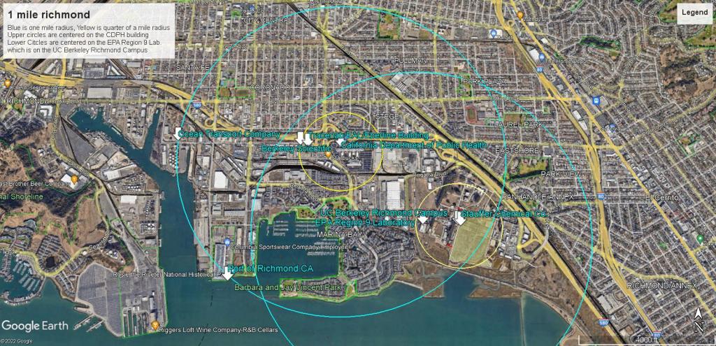
Near Neighbors are everything from 200 feet to a quarter of a mile and that makes the EPA Region 9 Laboratory within that range.

A Second Near Neighbor class is everything from a quarter of a mile to a mile away and that encompases the California Department of Public Health.

Then you have ranges for water and dust contamination that can go 4 miles, so these sites are all within a mile of the California Department of Public Health and all sites are within the wind range contamination of each other and the city of Richmond.


Featured

Nuclear Fuel Rods Transported to and from the Port of Richmond CA

GE Nuclear in Vallecitos Nuclear Center in Pleasanton, transported Nuclear Reactor Fuel Rods to Richmond to be sent to France to be processed in their Breeder Reactors and then sent back to GE through the Port of Richmond. To move nuclear materials you have to lay out the route and if you ever have seen the movie Superman these trucks are oversized. This also happened in the Port of Oakland. the shipping agreements are below.

They expected more shipments under this regulatory supervision.

Continue reading “Nuclear Fuel Rods Transported to and from the Port of Richmond CA”

Silicon Valley Toxic Waste Sites Map

Flickr image 4.5 MB or click on image below

silicon valley dark

Silicon Valley Composite image of GeoTracker map showing toxic waste sites. Geotracker uses Google images.

Apple is located on GE Intersil Superfund site that received radiological isotope Kr 85 from the DOE


“List of DOE Radioisotope Customers w/Summary of Radioisotope Shipments,FY85.”
D. A. Baker
08/31/1986
Prepared for the U. S. Department of Energy under Contract DE-AC06-76RLO 1830

Page 2.4 Item number 53.
G. E. Intersil Inc.
10710 North Tantau Avenue
Cupertino, CA 95014


Given that the Superfund site is the G. E. Intersil site, this associates it with the San Jose G. E. nuclear reactor assembly plant where they were assembling portable nuclear reactors for the US Army, a project started in the mid 1950s when radiological contamination levels were very relaxed and when they were strengthened in 1959 to 1/3 of what they were before, so all of these reactors were too hot for safe use. The entire program was scrapped by 1965. But this program required a large amount of new electronics and this brought about the beginnings of Silicon Valley.

Unfortunately for the people of San Jose they were dumping waste directly into the sewer system using 1955 standards which are nuclear accidents today. That is the problem with nuclear radiation, the clean up standards of the past, including the most recent past have been less and less radiation so that a site cleaned up 25 years ago is an accident today!

These were portable nuclear reactors that you could put on a truck, a transport plane, a ship or a train and bring it to a military site that had a deep pool with all of the necessary hook ups to set up a nuclear reactor to power the base or for colleges and universities. These reactors had no meaningful shields and were a serious radiological hazard to modern specifications.

San Jose CA – GE Nuclear Fuel Processing Facility at The Plant Shopping Center

There were several other portable nuclear reactor plants in the Bay Area, two I featured in this article Two nuclear reactors sites, 369 Whisman Road Mountainview (now Google) and San Ramon CA where the EPA should also look into assessing the damage to the environment and the people who now live within range of those reactor sites. The 369 Whisman Road reactor site had a high curb surrounding the building to contain the radioactive waste!

The EPA has regulations on conducting radiological surveys for sites and basically everything within 200 feet of a site is considered on the site, that goes for chemical contamination as well as radiological. DTSC has interpreted this to mean the property lines of toxic waste sites but the EPA has different rules. Then there is the distance from the contamination to a quarter of a mile is considered a near neighbor and the distance from a quarter of a mile to a mile is also a near neighbor but with a different set of calculations. The danger is evaluated based on the population near a site so in the case of Apple, this could be a big problem for them. How many people work in their Wheel?

The Federal Law, 40 CFR Appendix A to Part 300 – The Hazard Ranking System which is used to determine if a site is subject to Superfund status, the range of contamination goes out to various distances from the exact contamination site.

It depends on what happened to the Kr 85 which is a Byproduct Material, meaning it came out of a nuclear reactor and cannot be dumped in low level radiation facilities but would have to be disposed of most likely in the Nevada Test Site.

In order to use an isotope like this, the facility would require a hot cell which is a device or room to store radiological isotopes usually with mechanical hands to remove the isotope from the container and use it in whatever industrial process GE was using at the time and the necessary Geiger counter device to measure the Beta radiation from this isotope. It has a half life of 10 years so its still hot. Some hot cells are portable and look like aquariums or those isolated rooms with hands you see in movies or TV shows.

I outline the distances using San Francisco as an example showing the ranges of contamination that can result from Chemical, Biological and Radiological contamination in this article:
“Downtown San Francisco within Contamination Range of Treasure Island Atomic, Biological and Chemical Warfare training sites”

If the radiation was used on a device that has since decomposed in the soil, then you have the larger ranges of water and air contamination that can go out 4 miles from the site.

The Question is, does the EPA know that the isotope was used on the site. Given the other sites in the Bay Area I would give my opinion as to say no, but this will have to be looked into.

If the Nuclear Regulatory Commission had done its job, then there would be a set of inspections and a series of surveys to confirm the radiological isotopes were disposed of property and how they were used.


San Jose CA – GE Nuclear Fuel Processing Facility at The Plant Shopping Center

Atomic Power Equipment Department of the General Electric Company
175 Curtner Avenue which is today “The Plant Shopping Center” How can the state do things like this? Here is the State of California’s Envirostor map of the location https://www.envirostor.dtsc.ca.gov/public/map/?global_id=80001780&zl=16

INDUSTRIAL RADIOACTIVE WASTE DISPOSAL 2503 RADIOACTIVE WASTE DISPOSAL PRACTICES FOR THE ATOMIC POWER EQUIPMENT DEPARTMENT GENERAL ELECTRIC COMPANY SAN JOSE, CALIFORNIA 

This site was associated with the GE Vallecitos Nuclear Reactor site which is located near Sunol which is next to the San Antonio Reservoir. Let us hope that the creek does not empty into the water supply! In this map the site is near the middle 84 marker on this map and you can see Little Valley Road to its west.

How could the state of California allow a shopping mall to be built on top of a Uranium processing plant in the middle of the city of San Jose CA?. The site dumped radioactive waste directly into the city’s sewer system according to 1957 standards for disposal of nuclear waste into city sewer systems.

But 1957 standards for radiation exposure are nuclear accidents today. For example, in 1957 the maximum exposure for workers to be 1500 mrem of radiation a week for a person to be safe, that’s 18 full Rems a year. Today 5 REMS is the maximum amount for a nuclear worker a year but for civilians living on the site 0.1 REM or 100 mrems per year is the limit for safety for members of the public, the people of San Jose. 1 REM is 1000 mrems.

When the state says it was made safe, ask them what year and what were the standards back then!

Today’s nuclear radiation exposure levels from the Federal Register

Continue reading “San Jose CA – GE Nuclear Fuel Processing Facility at The Plant Shopping Center”

FAIRCHILD SEMICONDUCTOR CORP. (SOUTH SAN JOSE PLANT) SAN JOSE, CA

Groundwater Contamination Map, Toxic Plumes Map Source: The Chemical Legacy of Old Silicon Valley, NBC Bay Area, Map Editor Scott Pham 2019 https://www.nbcbayarea.com/on-air/as-seen-on/toxic-plumes_-the-dark-side-of-silicon-valley_bay-area/87485/

Google Map reference

Geotracker Deed Restrictions

ACTIVITIES PROHIBITED WHICH DISTURB THE REMEDY AND MONITORING SYSTEMS WITHOUT APPROVAL
DAY CARE CENTER PROHIBITED
ELDER CARE CENTER PROHIBITED
HOSPITAL USE PROHIBITED
LAND USE COVENANT
MAINTAIN MONITORING OF GROUNDWATER
NO GROUNDWATER EXTRACTION AT ANY DEPTH WITHOUT APPROVAL
NOTIFY AFTER CHANGE OF PROPERTY OWNER
ONLY EXTRACTION OF GROUNDWATER FOR SITE REMEDIATION PERMITTED
PUBLIC OR PRIVATE SCHOOL FOR PERSONS UNDER 21 PROHIBITED
RAISING OF FOOD PROHIBITED
RESIDENCE USE PROHIBITED

POTENTIAL CONTAMINANTS OF CONCERN
1,1,1-TRICHLOROETHANE (TCA), 1,4-DIOXANE, DICHLOROETHENE (DCE), FREON

The Chemical Legacy of Old Silicon Valley showing the Toxic Plumes, areas of groundwater contamination in Silicon Valley

https://www.nbcbayarea.com/on-air/as-seen-on/toxic-plumes_-the-dark-side-of-silicon-valley_bay-area/87485/

NBC Bay Area Video on the Toxic waste sites all over Silicon Valley. They had an interactive map but they took it down from their website.

Original article: NBC map showing the hundreds of sites on a map so you can see if you are affected by the pollution of Silicon Valley. https://www.nbcbayarea.com/brchannel/Map-The-Chemical-Legacy-of-Silicon-Valley-258950021.html From this map you can see that Apple and Google Headquarters are located on 2 superfund sites each where the polution is TCE Trichloroethylene where there are restrictions that require no person under the age of 21 can occupy any building built on the properties.

There is Kaiser Permanente building for Children and Adult psychiatric care built right on top of the street address of three sites and two of them are under Apple which is across the street. Note the tabs to show the daycare facilities that are on the purple areas that are mapped out to show the pollution.

The Map Article was taken down by NBC Bay Area.