Site History
Envirostor (State of California) page for: TYCO ELECTRONICS CORPORATION (80001600)
300 CONSTITUTION DR
MENLO PARK, CA 940250000
Google Map

“Tyco, previously known as Raychem, is an electronics manufacturer. Raychem had a hazardous waste facility permit and closed its hazardous waste management units at this site. DTSC has been overseeing corrective action at Tyco under a corrective action consent agreement. The main contaminant is PCBs. Soil removal was completed to industrial levels. A land use covenant has been entered into and filed with County. Tyco is currently conducting long term groundwater monitoring.”
Deed Restriction / Land Use Covenant:
Envirostor (State of California) Land Use Restriction Page
Land Use Covenant Amendment 8/6/2012
- ACTIVITIES PROHIBITED WHICH DISTURB THE REMEDY AND MONITORING SYSTEMS WITHOUT APPROVAL
- DAY CARE CENTER PROHIBITED
- HOSPITAL USE PROHIBITED
- LAND USE COVENANT
- MAINTAIN MONITORING OF GROUNDWATER
- NO EXCAVATION OF CONTAMINATED SOILS WITHOUT AGENCY REVIEW AND APPROVAL
- NO EXCAVATION OR ACTIVITIES WHICH DISTURB THE SOIL BELOW A SPECIFIED DEPTH (SEE COVENANT FOR DEPTH) WITHOUT AGENCY REVIEW AND APPROVAL OF A SOIL MANAGEMENT PLAN
- NO GROUNDWATER EXTRACTION AT ANY DEPTH WITHOUT APPROVAL
- NO OIL OR GAS EXTRACTION AT ANY DEPTH
- NOTIFY DAMAGES TO REMEDY AND MONITORING SYSTEMS UPON DISCOVERY
- NOTIFY PRIOR TO SUBSURFACE WORK
- PERFORM H&S PLAN PRIOR TO SUBSURFACE WORK
- PUBLIC OR PRIVATE SCHOOL FOR PERSONS UNDER 21 PROHIBITED
- RAISING OF FOOD PROHIBITED
- RESIDENCE USE PROHIBITED
Institutional Controls Estab-Goverment Control (CA772GC) 1/19/2007
- ACTIVITIES PROHIBITED WHICH DISTURB THE REMEDY AND MONITORING SYSTEMS WITHOUT APPROVAL
- DAY CARE CENTER PROHIBITED
- HOSPITAL USE PROHIBITED
- LAND USE COVENANT
- MAINTAIN MONITORING OF GROUNDWATER
- NO EXCAVATION OF CONTAMINATED SOILS WITHOUT AGENCY REVIEW AND APPROVAL
- NO EXCAVATION OR ACTIVITIES WHICH DISTURB THE SOIL BELOW A SPECIFIED DEPTH (SEE COVENANT FOR DEPTH) WITHOUT AGENCY REVIEW AND APPROVAL OF A SOIL MANAGEMENT PLAN
- NO GROUNDWATER EXTRACTION AT ANY DEPTH WITHOUT APPROVAL
- NO OIL OR GAS EXTRACTION AT ANY DEPTH
- NOTIFY AFTER CHANGE OF PROPERTY OWNER
- NOTIFY DAMAGES TO REMEDY AND MONITORING SYSTEMS UPON DISCOVERY
- NOTIFY PRIOR TO CHANGE IN LAND USE
- NOTIFY PRIOR TO DEVELOPMENT
- NOTIFY PRIOR TO SUBSURFACE WORK
- ONLY EXTRACTION OF GROUNDWATER FOR SITE REMEDIATION PERMITTED
- PERFORM H&S PLAN PRIOR TO SUBSURFACE WORK
- PUBLIC OR PRIVATE SCHOOL FOR PERSONS UNDER 21 PROHIBITED
- RAISING OF FOOD PROHIBITED
- RESIDENCE USE PROHIBITED
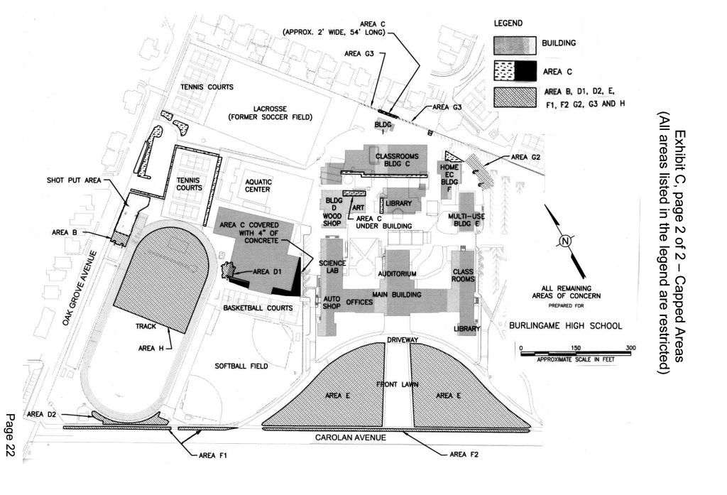
POTENTIAL CONTAMINANTS OF CONCERN
As a result of historical operations at the Property, certain hazardous
materials, including volatile organic compounds, semi-volatile organic compounds, PCBs, dioxins and dibenzofurans were released into the soil and groundwater at the Property.

You must be logged in to post a comment.